The Somalayas are the biggest mountain range you will never see
The Somalayas are the biggest mountain range you will never see
Author: Douwe van Hinsbergen, Chair in Global Tectonics and Paleogeography, Utrecht University
Douwe van Hinsbergen, Author provided
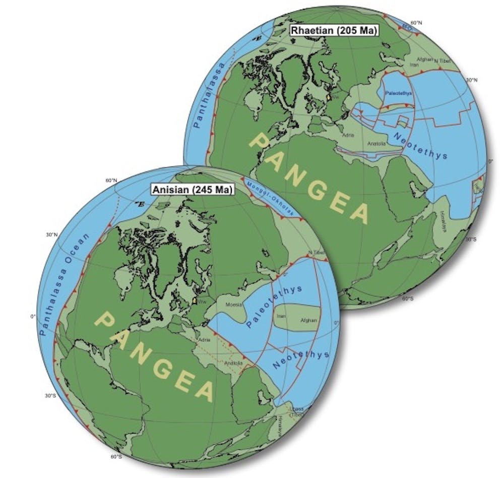
Every geography schoolbook has them: maps that look like today’s Earth, but not quite, since all continents are merged into a single supercontinent. Those maps were used to explain why dinosaurs in South America and Africa, or North America and Europe looked so alike.
“Paleogeographic” reconstructions like these provide context to study the processes that shape our planet: the Earth’s engines of plate tectonics, volcanism, and mountain building, and their interactions with the oceans, atmosphere, and sun that shape climate and life. In the past ten years software has been developed that means anyone who is interested can make these reconstructions.
van Hinsbergen et al (2019), Author provided
But if paleogeographic maps were already in our primary school textbooks, then what are geologists like me trying to uncover? Just the details?
To some extent: yes, working out the details of plate motions in the distant past may make all the difference. For instance, major ocean currents can suddenly change course when narrow oceanic corridors open or close, such as between the Americas or when water suddenly flooded through the Straits of Gibraltar and filled up the Mediterranean. And subtle differences in the timing or location of such corridors may support or falsify what we think caused past changes in climate.
But the biggest problem for paleogeography is not the details: it’s that as much as 70% of the Earth’s crust that existed as “recently” as 150-200 million years ago, when dinosaurs were already roaming the planet, has been lost to subduction into the Earth’s inner mantle. On paleogeographic maps, we have filled in those now-subducted areas, usually in broad brush strokes using the simplest possible scenarios without much detail. But there are relics of this subducted crust left in the geological record, and in my field of research we try to use these records to learn about Earth’s “lost” surface.
Many mountains, most famously the Himalayas, are made of folded and stacked slices of rock that were scraped off the subducted plate. And the types of rock and the fossils and minerals they contain can tell us when and where these rocks formed. Geologists can then piece together how those continents and deep basins and volcanoes linked together in the distant past.
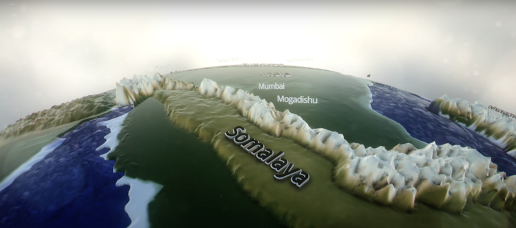
Somalayas, 200 million years from now
In recent years, when I explained how we make reconstructions of paleogeography from modern mountain ranges, I was sometimes asked if we could also predict future mountains. I always said “sure, but why would I? I’d have to wait a hundred million years to see if I’m right”.
But then I realised that this could be an interesting thought experiment. Predicting the architecture of future mountain ranges would require formulating a set of “rules of mountain building”, which had not been done before. And we would have to predict how the geography we know well would transform into mountain belts, which would make us realise what the plates that were lost forever could have looked like, particularly the parts that subducted without leaving a record. And would we produce mountain belts that look much like the ones we have?
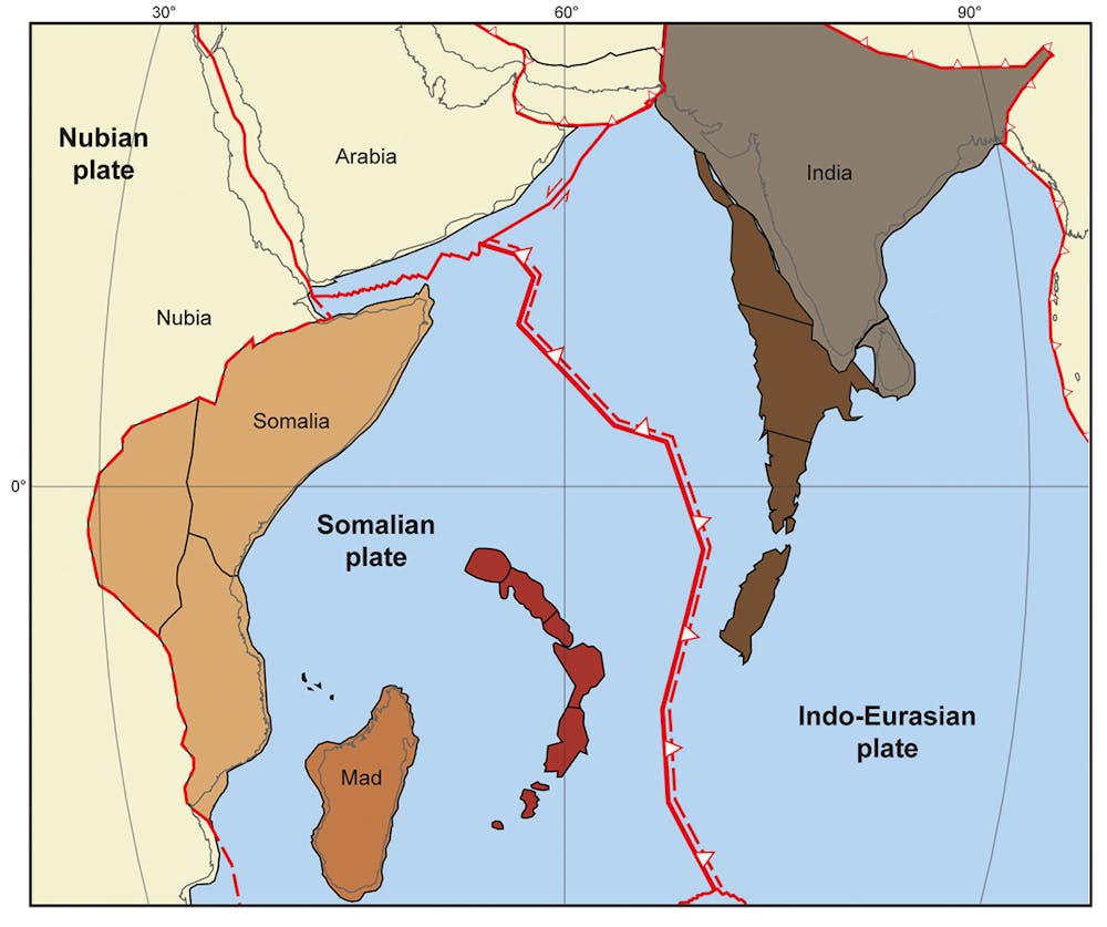
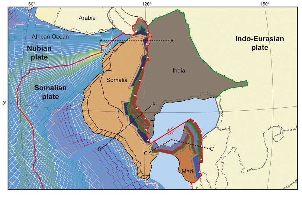
So we did. I formulated the rules by comparing which features are commonly found in mountain belts. My then-MSc student Thomas Schouten used the rules to predict the geological architecture of a mountain belt that will form in the next 200 million years, if Somalia, as expected, breaks off from Africa and collides with India.
Douwe van Hinsbergen, Author provided
The resulting mountain range, which we called the “Somalaya mountains”, might be the Himalayas of their day. And seeing such similarities between the Somalaya and known mountains today can us with provide possible solutions we never thought of for paleogeographic evolution.
Douwe van Hinsbergen, Author provided
For instance, according to our research, a mountain belt may form in the bay between Madagascar and Africa, and it would be strongly curved much like the Carpathians of Eastern Europe or the Banda islands of Indonesia and Timor. And northwest India will first get deeply buried 50 km or so below Somalia, but then Somalia will rotate and northwest India will re-emerge – this is a geological history that looks much like western Norway around 400 million years ago.
Thought experiments like our look at the Somalayas help us to realise what we overlook when reconstructing the history of the Earth’s plates and surface. The better those reconstructions, the better we will predict Earth’s history and behaviour, its resources, and the effects of using them.![]()
This article is republished from The Conversation under a Creative Commons license. Original article.
More on the subject:
Gone with the waves: the ups and downs of oceans and corals
How the Mediterranean was refilled