49 open questions in geoscience
49 open questions in geoscience
What keeps Earth-scientists busy? The present list aims at summarizing the most relevant open problems addressed by geoscientists nowadays. Some of these 49 open questions are recent; others have been standing unanswered for centuries. They cover from the early stages of the Earth to the present or near future threats; from the deeper interior of the planet to the processes that shape its surface.
The Early Earth and the Solar System
- How did Earth and other planets form? Were planets formed in situ? Or are orbital changes relatively frequent? What determined the different deep layering of the solar planets? [recent Science paper on Mercury]
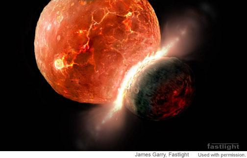
- Was there ever a collision of the Earth with another planet Theia, giving birth to our satellite? [ref] There is compelling evidence, such as measures of a shorter duration of the Earth’s rotation and lunar month in the past, pointing to a Moon much closer to Earth during the early stages of the Solar System.
- What is the long-term heat balance of Earth? How did its internal temperature decay since it formed by accretion of chondrites? How abundant are radiogenic elements in the interior? Did a “faint young sun” ever warm a “snow-ball Earth”? [ref]
- What made plate tectonics a dominant process only on Earth? [outreach paper] How did the planet cool down before plate tectonics?[ref] Was the Earth’s crust formed during the early stages of its evolution or is it the result of a gradual destillation of the mantle that continues today along with crustal recycling? Is the crust still growing or does its recycling compensate for crust formation at mid-ocean ridges and other volcanic areas?
- How inherent to planetary evolution is the development of life conditions? [ref.1, ref.2] Earth-like planets are now known to be abundant in our galaxy (two out of three stars may have one [e.g., Nature, 2012]), but how many of them develop widespread, durable water chemistry?
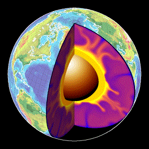
Earth’s Interior
- As planets age and cool off, their internal and surface processes coevolve, chemically and mechanically, shaping the atmospheric composition. What are the chemical composition and mechanical properties of rocks in the Earth’s mantle at the extreme pressure and temperature they undergo? [ref.2]
- What are the dynamic processes in the Earth interior that accommodate and fuel plate tectonics? As seismometers spread more evenly over the planet’s surface, the seismic imaging of the interior will rapidly improve, providing a detailed distribution of seismic wave velocity. Simultaneously, lab-based mineral physics must better constrain what these mechanical wave velocities tell us about the hot, deep rocks of uncertain composition in the mantle. Only then will computer models be able to test the proposed geodynamic models by trying to fit quantitatively those data and other geophysical observations such as gravity variations. [ref.3]
- How does the geomagnetic field link to the iron convection properties at the deep Earth? Or what can we learn about the mechanical behavior of the materials at those depths from the geomagnetic field? [more context in Nature] Geomagnetic changes are recorded in rocks, so they provide a view of the old Earth: Are the magnetic reversals too fast to be related to core dynamics? [example.1] [ex.2] [ex.3] Could their frequency be related to the distribution of tectonic plates? [GRL article]. What causes superchrons (periods without reversals)? Something internal to the core, or induced externally by the mantle/subducting slabs? Was the geomagnetic field always dipolar, or was it more asymmetric in the past?
- Are intraplate hotspots really made by deep sources of uprising materials (mantle plumes) coming from the deepest Earth’s mantle? Or can they be explained by shallower convection? [e.g., Morgan, 1971; see also this recent Geology paper on Yellowstone].
- What is the history of and what controls the excursions of the rotation pole relative to the surface geography, known as true polar wander? [ex]
- What tells us about the dynamics of the Earth its present heterogeneity in density, composition, and seismic wave velocity in the mantle and the lithosphere? [ex.3] What is the nature of the lithosphere / asthenosphere boundary?
- What are the causes for Large Igneous Provinces and massive flood basalts such as the Columbia River Basalts?
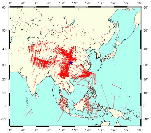
from GPS data. Blue star indicates the 2008 China earthquake. | Credit: Caltech
Tectonic plate motion and deformation
- How relevant is the mantle drag in driving plate tectonics? [e.g., Negredo et al., GRL, 2004, vs. van Benthem & Govers, JGR, 2010]. Does continental collision diminish the rate of plate subduction, as suggested by the slab-pull paradigm? [Walter Alvarez, EPSL, 2010]
- What happens after the collision of two continents? How frequent are the processes of mantle delamination and slab break-off? What determines their occurrence? [Magni et al., GRL, 2013; Durezt & Gerya, Tectonoph., 2013]
- Why are orogens curved when seen from space? [Weil & Sussman, 200, GSASP 383] What determines the structure of orogens? [Mouthereau et al., Nature Geosc., 2013]
- How does the long-term deformation derived from paleomagnetism and structural geology link quantitatively to the present-day motions derived from GPS and from neotectonic patterns of crustal deformation? [Calais et al., EPSL, 2003] How do these last two relate to each other? [ref] Can we learn from regional structure of the crust/lithosphere from that link (or viceversa)?
- Are plate interiors moving in steady-state linear motion? How rigid are these and why/when did they deform? [Davis et al., (2005) doi:10.1038/nature04781, and Wernicke & Davis, (2010) doi:10.1785/gssrl.81.5.694].
- How is the relative motion between continents accommodated in diffuse plate boundaries? (eg., the Iberian/African plate boundary). What determines the (a)seismicity of a plate contact?
- How/when does deformation propagate from the plate boundaries into plate interiors? [e.g., Cloetingh et al., 2005, QSR]
- What is the rheological stratification of the lithosphere: like a jelly sandwich? Or rather like a creme brulée? [Burov & Watts, 2006]. Is the lower crust ductile? Is strength concentrated at the uppermost mantle? Or just the other way around? [e.g., McKenzie et al., 2000; Jackson, 2002; Handy & Brun, 2004; and a nice recent post].
- Does climate modify tectonics? Does the deposition of sediment on the flank of mountains stop the frontal advance of the orogen? Does vigorous erosion cause deformation by shortening to be concentrated in the core of mountain belts and prevent the propagation of shortening into the undeformed forelands? Is there any field evidence for the effects that computer models predict for erosion and climate to have on the patterns of tectonic deformation? [Philip Allen’s blog] [Willett, 1999; Whipple, 2009; Garcia-Castellanos, EPSL, 2007]
- Can earthquakes be predicted? [ex.4, ex.5]. Little is known about how faults form and when do they reactivate [ex.6], and even worse, there seems to be no clear pathway as to solve this problem in the near future. Unexpected breakthroughs needed.
-
How can the prediction of volcanic eruptions be improved? What determines the rates of magma accumulation in the chamber and what mechanisms make magmas eruptible? Where are (or were) the magma chambers of supervolcanos? [ex.7][ex.7b][ex.7c]
- The elevation of the continents does not always match the predictions from the principle of isostasy (Archimedes) for the Earth’s outer rigid layer (the lithosphere). This deviation is known as dynamic topography. But what are the mechanisms responsible? Can we learn about the mantle dynamics by estimating the dynamic topography? Or inversely: Can we predict it from mantle flow indirect estimations? Can dynamic topography significantly influence erosion rates, thus being retrained in the geological record?
-
How do land-forming processes react to climate change at a variety of scales, ranging from the Milankovitch cycles to the late Cenozoic cooling of the Earth? Is there a feedback from erosion into climate at these time scales, through the Carbon cycle and the weathering of silicates, for example?
Earth’s landscape history and present environment
The shape of the planet’s solid surface, its topography, is the key feature that connects many of the disciplines within Earth science, probably because it is the feature that most affects our daily life.
- It is common wisdom that landscape forms in a complex interplay between tectonics, climate, and a list of mechanical, chemical, and biological processes acting at the surface of the Solid Earth. Topographic data is becoming now available at resolutions finer than a few meters. The sedimentary record is also growing at unprecedented rates. But can we use these data to derive past tectonic and climatic conditions? Will we ever know enough about the surface processes? Was also the stocasticity of meteorological and tectonic events relevant in the resulting landscape? And how much has life contributed to shape the Earth’s surface?
- Can classical geomorphological concepts such as ‘peneplanation’ be understood quantitatively? Old mountain ranges such as the Appalachian or the Urals seem to retain relief for > 10^8 years, while fluvial valleys under the Antarctica are preserved under moving ice of kilometric thickness since the Neogene. What controls the time-scale of topographic decay? [Egholm, 2013, Nature]
- What are the erosion and transport laws governing the evolution of the Earth’s Surface? [Willenbring et al., Geology, 2013] Rivers transport sediment particles that are at the same time the tools for erosion but also the shield protecting the bedrock. How important is this double role of sediment for the evolution of landscapes? [Sklar & Dietrich, Geology, 2001 (tools and cover effect); Cowie et al., Geology, 2008 (a field example)].
- Can we predict sediment production and transport for hazard and scientific purposes? [NAS SP report, 2010]
- What do the preserved 4D patterns of sediment flow tell us from the past of the Earth? Is it possible to quantitatively link past climatic and tectonic records to the present landforms? Is it possible to separate the signals left in river profiles by both climate and tectonics? [e.g., Nature Geosc].
-
Can we differentiate changes in the tectonic and climate regimes as recorded in sediment stratigraphy? Some think both signals are indeed distinguishable [Armitage et al., 2011]. Others, as Jerolmack & Paola [2010, GRL], argue that the dynamics intrinsic to the sediment transport system can be ‘noisy’ enough to drown out any signal of an external forcing.
- Does surface erosion draw hot rock towards the Earth’s surface? Do tectonic folds grow preferentially where rivers cut down through them, causing them to look like up-turned boats with a deep transverse incision? [Simpson, 2004, Geology]
-
What caused the huge salt deposition in the Mediterranean known as the Messinian Salinity Crisis? Was the Mediterranean truly desiccated? What were the effects on climate and biology, and what can we learn from extreme salt giants like this? [e.g., Hsu, 1983; Clauzon et al., Geology, 1996; Krijgsman et al, 1999; Garcia-Castellanos & Villaseñor, Nature, 2011]
- Can we quantitatively reconstruct past ecology or climate from old river patterns? [e.g., Hartley et al., 2010, J. Sedim. Res.]
-
Do we need a new geological epoch called Anthropocene? When should it start? 8000 bp (Ruddiman, 2003); 2000 bp (Scalenghe, 2011); 1850 AD (Crutzen & Steffen, 2003)?

Climate, Life, and Earth
The geological record shows that climate is relatively stable over tectonic time-scales while undergoing abrupt changes in periods as short as decades or millenia. Past periods when the planet underwent extreme climate conditions may help to understand the mechanisms behind that behavior.
- What caused the largest carbon isotope changes in Earth? [Nat.Geo review]
- Was there ever a snow-ball Earth during the earliest stages of Life?
- Were there also rivers and lakes on Mars? Were there large outburst floods similar to those on Earth?
- What were the causes and what shaped the recovery from mass extinctions as those at the K-T boundary, the Permian-Triassic or the Late Triassic? [recent papers: ex.8, ex.9, ex.10]
- What triggered the extreme climatic variability during the Quaternary and the roughly coeval acceleration in continental erosion and sediment delivery to the margins of the continents? [Peizhen, Molnar et al., 2001] Was this related to the tectonic closure of the Central American Seaway?
- How do climate changes translate quantitatively into sea level changes?
- What caused the Quaternary extinction(s)? Human expansion? Climate Change? Was the large fauna extinction ~13,000 yr ago a result of the Younger Dryas climatic event? Was this caused by an extraterrestrial impact? [ex.11, ex.12] Or may it be linked to the outburst of Lake Agassiz?
- How relevant are subsurface microorganisms to earth dynamics by controlling soil formation and the methane cycle?
- The atmosphere is shaped by the presence of life, a powerful chemical force. Earth’s evolution has clearly affected the evolution of life [see the Cambrian explosion of animal life, for instance; plus this recent paper on that]. To what extent is evolution determined by geology? How much control has life on climate? [another recent one]. Is it possible to quantify these links to make reliable predictions that allow filling the data gaps or assessing the chances of extraterrestrial life?
- How much of the present climate change is anthropogenic? How will growing emissions from a growing global population (and with a growing consumption) impact on climate?
Broader questions.
- Many of the questions above are related to the extreme diversity of spatial scales of Earth processes. Direct observation (by sampling or remotely) is mostly limited to a thin layer around the solid surface of the Earth, and physical experimentation is limited to the pressures of the uppermost layers of the planet. Many processes including plate tectonics are known to be driven by the nature of the materials that make up the planet interiors, down to the smallest atomic scales, as thought for instance for the trigger of earthquakes. Answers may arrive via new devices and analytical tools working at the high pressures and temperatures of Earth’s interior.
- Time scales also pose a problem to know the mechanical and chemical properties of Earth’s materials. Partly because we deal with time scales in very different orders of magnitude while we are limited to make observations from the present. But also because scaling the rates of lab experiments (e.g., mineral physics) or analogue models (e.g., sandbox experiments) with the corresponding geological scenarios is not always convincing.
- Implementing Episodicity in Gradualism: For historical reasons, geology has generally underestimated the role of episodicity in nature. However, there is a growing view that exceptional events have a relevant effect in many of Earth’s subsystems. An example for this is the preeminence of flooding events in surface sediment transport during the evolution of landscape. Climate variability at all time-scales has been already mentioned above. Even plate tectonics may have been episodic (during the Archean at least, [ref]). 4D hyperscale data sets in geomorphology are increasingly showing the limits of smooth-process approaches. Future understanding of the Earth will benefit from incorporating the full frequency spectrum (the episodicity) in modeling natural phenomena, rather than systematically approaching these as gradual processes.
- Computer models tell whether the complexity of nature can be explained by the interplay between simple processes, but: how can we further model the Earth as a complex system of complex systems? And when can we expect ‘compact’ explanations?
It is not possible to discuss here all the abundant and interesting links and interdependencies among these questions and the processes involved.
General references:
Note that the specific references given above for each open question are sometimes just examples and may not always be the best representative. Furthermore, the list is surely biased towards Solid Earth Science, my own field. The following general references can give you an alternative perspective on the subject.
- BESR (2008). Origin and Evolution of Earth: Research Questions for a Changing Planet The National Academies Press DOI: 10.1002/gj.1188
- Science 125th anniv. compilation.
- NAS report Origin and evolution of Earth [pdf] [html]
- NAS report on surface processes
- Earth Magazine 2012 article.
Acknowledgements:
For various inputs to this list: Brian Romans, Umberto Lombardo, Jean Braun, Mikael Attal, Alexandra Witze, Michael Klaas, Matt Hall, Chris Rowan.
3 comments
I’m an 18 year old from salt lake city utah. I am curious about the possibility of snow ball earth in the book a short history of nearly everything by Bill Bryson. It talks about how the ice may have been translucent allowing sunlight to travel through the ice that algae used to photosynthesis and keep life from going extinct. How may that have happened? I think that it is more likely that there were hot spots caused by volcanic activity that kept water from freezing.
Why do manny Earth maps of Pangaea show a “same size” Earth. Could it be possible, that Earth has gained volume over time ? Perhaps more Is / Water og Stone. And if…The Earth was smaller = les gravity. Could this explain bigger animals earlier ?
The volume gained by the Earth at least since life originated is negligible.
Bigger animals earlier were likely due to more available oxygen in the atmosphere (but there is no conclusive evidence.)